I have checked it out for you–I have driven across the emptiest stretches of the map, those maximally bereft of gas stations, and I have determined that you can ALWAYS get from one gas station to the next.
Just last weekend I traversed the longest empty spot on the map that I’ve ever found. En-route to meeting friends for a canyoneering trip in the middle of Escalante, I elected to do some adventure driving on a new route that I had never been on before. This is saying something—I have driven around the west an awful lot—for example I have driven across the country east to west twenty-seven times. I had been down Hole-in-the-Rock-Road (“HITRR”), which shoots southwest from the town of Escalante, a number of times. But I had never been in any of the enormous empty stretch to the southwest of there, everything between HITRR and the nearest semi-circle of pavement–that’s an area of 800 square miles. I felt an itching need to get out there, fill in my mental map of what’s there was to see.
DOWNLOAD .kml file for google earth, etc
DOWNLOAD .gpx file for GPS, iOs apps, etc
If you do a google maps directions search for driving between Los Alamos, NM and Escalante, UT, you’ll see a wildly circuitous route of ~10 hours. The recommended route detours far to the north or south, to get around Lake Powell and then around the emptiness of the Escalante desert. That region of the country is the most difficult-to-cross desert that exists in this country.
So I sat down with google earth, and with a whole lot of zooming in and out, I managed to string together a lot of dubious dirt roads to trace a path from Big Water, west of Page, to meet up with Hole-in-the-Rock-Road south of Escalante. I laid down a string of waypoints at all the junctions, to be uploaded to my GPS and guide my way even in the absence of cell service for downloading additional information. Not truly old-school (I was using a GPS for example), but there is certainly no cell-service out there–no way to download new maps to check out road junctions to decide which way to go, for example. The waypoints that I marked ahead of time are the yellow pins on the map; the blue track is the actual route that I ended up taking. I’ll write a post sometime about the way I do my planning and my complete system for handling navigation.
By the numbers, the path was a considerably shorter distance than driving all the way around, per the recommended driving directions. Of course, I had no illusions that it would be faster–I wasn’t doing it to save time, I was driving alone and had some extra time to spare. I figured that if the roads were passable at all, I wouldn’t lose too much time and that was fine. On the other hand, if I got blocked or stuck somewhere way out there, it would be an extra super long day…
To be prepared—and I am really big on being prepared—I grabbed my cheap red plastic lawnmower gas can, already full, out of my garage, and strapped it atop my roof rack.
The driving route was fantastic. Check out the map. It took me 2.5 hours to get from Big Water to the intersection with HITRR. I did not see a single other vehicle that entire time.
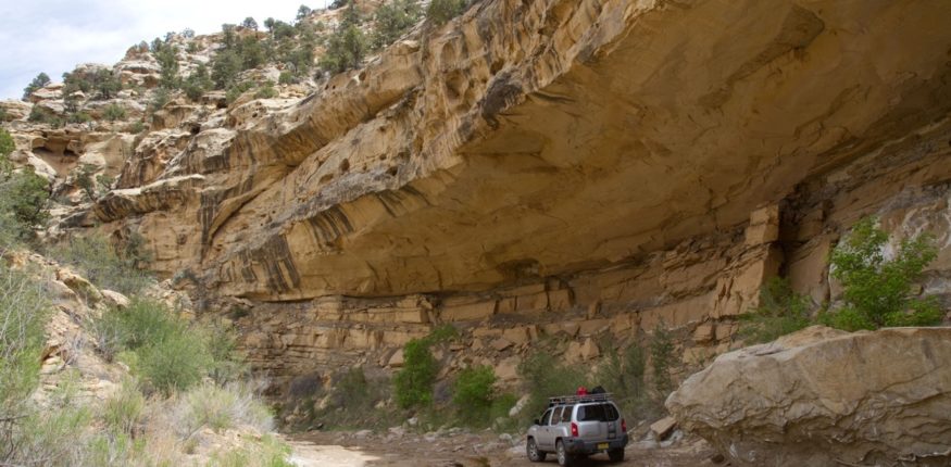
The passing got iffy a couple of times. Two separate times, the road just gave up and went straight down the drainage of a canyon, through puddles and mud, through some narrow spots and even some stream crossings (surprising that there was actually water out there). Tighter and rockier and more wet, to the point where the road became invisible and I was just driving through a canyon bottom in the middle of the desert, an entirely natural road, with no tire tracks and no evidence that anybody had ever passed through. The chanciest spot was at the 2 hour mark, and so it was a huge relief when the canyon finally opened up and I made it through to an easy road on the east side.
The entire drive involved active driving–not the sort of one-hand-on-the-wheel, listening to a podcast sort of highway driving. We’re talking bumpy-ass, full-attention driving. Which is great, but 2.5 hours of that sort of driving produces a sort of road fatigue. Lots and lots of rocky, bumpy road, and not a single other soul out there. No vehicles, no buildings, not even a cow.
And intermittently, throughout that entire rough road, I would get whiffs of gasoline. That damn gas can on top of my roof was getting shaken around like crazy, and the littlest bit of gas would leak out and dampen the side of the container. Never enough to wet my roof, but just enough for me to regularly sniff it through the driver’s window. Which was the originally point of this whole post: gas cans are stupid. I crossed that whole desert, the biggest and emptiest, and never came close to needing the spare gas. So my advice: don’t ever bother with a spare gas can.
There’s a caveat of course: I’m assuming you don’t screw up. Don’t forget to fill up before you head across a blank stretch. Don’t get lost and drive around in circles for hundreds of unnecessary miles. As long as you keep your head on straight, you never need to bring an extra gas can. It’s stinky, messy, and pointless. I don’t care if there are better cans out there that won’t leak–you don’t need one.
Gallery:


